
Intro and background
GPS Requirements for Cycle Touring
Garmin NUVI 550
Garmin BaseCamp
Waypoint Strategies
Conclusions
Contact - additional links
A number of years ago, I bought a Garmin Edge 800 for cycling and cycle-touring.
After evaluating it for a number of days, I found :
.. so I returned it and ask a friend what he was using.
He introduced me to the Garmin NUVI 550 (500 is USA) which is a waterproof GPS designed for a motorcycle but works great on a bicycle.
After 3 years of creating routes with this unit, I've decided I have learned enough
to share some of my strategies with others. So here goes ...
GPS Requirements for Cycle Touring
... top
Basically, here are my requirements for a GPS while cycle touring with panier's and no laptop:
Although the NUVI 550 is no longer available, it is useful to understand what made it useful and how I use it cycle touring.
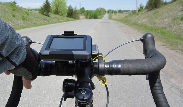
The NUVI 550 (500 for USA maps only) is basically a standard car GPS that happens to be waterproof.
It has a replaceable battery and a slot for additional flash memory that has enough capacity to store a huge number of Garmin map regions and routes.
It has a battery life of about 4 hours which is not quite enough for most days we cycle.
My friends approach to this problem is to simply replace the battery with a backup battery when it runs dry.
My approach has been to turn off the unit when the next way point (via in Garmin terminology) is more than ~3Km away and then note the odometer reading on my bike computer and calculate when I should turn it back on. Because the Garmin turns on and loads in about 30 seconds, this works surprisingly well. Also, because the Garmin can catchup to its current location on route, there are never any hick ups. Using this on/off strategy, I can often get two days of riding on a single charge. I also bring the spare battery.
You can now see why setting waypoints strategically on a route can effect how often I have to turn on and off the GPS. To this end, I don't want a route with an excessive number of waypoints as I would never turn off the unit. You can also see that if the route has many turns the battery life will be less as I am less likely to turn off the unit as often. In practice, this has not been an issue. There are always long stretches of 10Km or more of road that easily conserve the required energy to make the battery last.
My recent strategy for setting waypoints has been to put the waypoint
past the turn or point of interest by 100m or so. If I put the waypoint
in the middle of a road segment, then I will have to turn on the GPS more
often - or scroll to the next turn/announcement to see past the waypoint
to decide how long to turn off the GPS. Possible but more fiddling while riding!
Garmin BaseCamp
... top
Although I wanted the ability to create and alter routes while touring with the NUVI 550 on a bicycle without having to cart around a laptop, much of the initial route preparation I do with the Garmin laptop software before the trip. I can then modify waypoints or create new routes on the road if need be, but at least I have a base set of routes to start with.
I use BaseCamp as it is the more recent of the Garmin route-creation s/w packages, and, after a frustrating learning curve, I've come to live with it - with few hick-ups.
NOTE: when I load the route in NUVI 550, I always do an "edit/recalculate/shortest distance" to make sure the route comes out the same distance and shape as BaseCamp.
Sometimes it does not (because of slight algorithm differences) and so I then know I was too sparse in my usage of waypoints!
The other reason to do this is that the NUVI 550 will re-calculate if you deviate
from the route, which is what you want, so better to know before you start
riding if there is a re-calculate difference between the GPS and BaseCamp!
Waypoint Strategies
... top
When I first started placing waypoints to define a route, I placed them at the intersection of roads or the middle of a town. What I found was that often I would get a 'Make a U-Turn' from the GPS as I would come into the intersection. The other thing that would happen is that the NUVI 550 would not tell me if I was coming to a turn - just that I was approaching a waypoint - and then it would tell me to turn as I came onto the intersection.
The other thing I found is that often I would have no interest in where I passed through a town, I just wanted to make sure I came out the other end on the right road! Sometimes we would stop for lunch, take in a museum etc. and deviate from the 'centre' of the town. It would no longer made sense to go back to a waypoint placed in the centre of town. Also, sometimes the map data did not correctly identify one-way roads and throwing a waypoint in the middle of that mess only made things more confusing! So putting the waypoint on the other side of the town seems to be the best strategy and will always get you out of town on the road you want to be on!
The other strategy I tried was putting the Waypoint in the middle of the road segments I was interested in. This actually makes some sense as I choose roads to ride that are interesting (or so I think!). This also makes sense from a symmetry perspective because if you decide to 'reverse' the route direction, you probably still have the waypoints in the optimal positions. The only problem I had with this approach is I would be less likely to turn off the GPS to save power as my GPS would want to tell me about the waypoints as well as the intersection turns.
I finally have decided that the best strategy, as stated earlier, is to place the waypoint 100-200m past the intersection (or town).
Using this strategy, the NUVI 550 tells me when the next intersection is (in kilometres) and if it is a left or right turn. I usually then turn off the GPS and turn it back on when I get to the intersection, confirm the turn, ride until the waypoint announces, hear the distance to next turn and I can then decide if I want to turn off the GPS to save power.
The only problem with this strategy is if you want to reverse the
route direction you probably want to move all the waypoints to the
other side of the intersections!
Conclusions
... top
If you see an error in anything I have stated here, please let me know and I will correct it!
If you disagree with any statements I've made, please contact me and let me know your thoughts!
Please send comments and suggestions to: hb [at] nordicwind [dot] ca
Harold Blount - rev: 2014 April 29

| Copyright © 2007-2014 Nordicwind Inc. All rights reserved. | Legal | Privacy |